IPCC SRES scenarios
Greenhouse gases
Greenhouse gas emissions reduce the loss of heat of the Earth's atmosphere and create an inhabitable planet.
Greenhouse gases include carbon dioxide (CO2), nitrous oxide
(N2O), methane (CH4), sulfur oxides (SOx),
and various other gases. However, since industry revolution in the 19th century anthropogenic changes
of greenhouse gas emissions lead to a physical change of the atmosphere contents. Increasing greenhouse gas
concentrations likely contributed most to the global surface temperature increase of 0.74°C between
1906 and 2005 (IPCC 2007). For this reason, images of the future evolution of greenhouse gas concentrations
are essential for Earth's climate projections.
Emission scenarios
Details with regard to the IPCC SRES (Intergovernmental Panel on Climate Change Scenario Special
Report on Emission Scenarios) scenarios were published by Nakicenovic et al. (2000).
Driving forces of greenhouse gases are mainly demographic and socio-economic development, as well as
changes in technology and environment. Nakicenovic et al. (2000) have developed four different
narrative storylines (the so-called "families" are A1, A2, B1, and B2) that try to estimate the future
evolution of greenhouse gases. Six scenario groups were drawn from the four families. One group each in
A2, B1, and B2, as well as three groups within A1, which are characterised by different energy
technology developments: A1FI is a fossil fuel (including coal, oil, and gas) intensive, A1B is a balanced
energy supply mix, and A1T is a predominantly non-fossil fuel scenario. At the expense of carbon option
most of the scenarios, in particular B1 and to some extent also A1B follow a trend toward increases
of renewable and nuclear energies in the long term. Note, there is no "central", "best guess"
or "business-as-usual" scenario included and probabilities of occurrence are not assigned to individual
SRES scenarios.
|
|
|
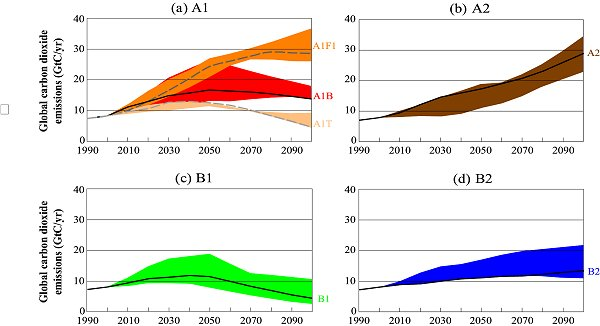
Fig. 1: Total global annual carbon dioxide emissions from all sources (energy, industry,
and land-use change) from 1990 to 2100 (in Giga tons of carbon (GtC/yr) for the families
and six scenario groups. The 40 SRES scenarios are presented by the four families
(A1, A2, B1, and B2) and six scenario groups: (a) the fossil-intensive A1FI (comprising the
high-coal and high-oil-and-gas scenarios), the predominantly non-fossil fuel A1T, the
balanced A1B; (b) A2; (c) B1, and (d) B2. Each coloured emission band
shows the range of harmonized and non-harmonized scenarios within each group. For each
of the six scenario groups an illustrative scenario is provided, including the four illustrative
marker scenarios (A1, A2, B1, B2, solid lines) and two illustrative scenarios for
A1FI and A1T (dashed lines) (Fig. SPM-3 in Nakicenovic et al. 2000).
|
|
Storyline characteristics
The A1 and B1 scenario families are based on low fertility and low mortality rates and exhibit the lowest
demographic trajectories. The global population increases to 8.7 billion by 2050 and declines afterward
toward 7 billion by 2100. By contrast world population of 2100 is increasing in the A2 and B2 scenario
families to 15 billion and 10.4 billion, respectively.
Technology will have a big impact on greenhouse gas emissions of the 21st century. The A1B scenario assumes
significant innovations in energy technologies leading to drastic increases
of modern renewable energies. By contrast family clean and resource-efficient technologies are introduced in the
B1 scenario family. As against A1B, the B1 storyline describes a less material-intensive economy.
The final energy use in the A1B scenario family is therefore much higher than that for B1.
Population growth and increases of meat demand in the developing countries result in substantial global
expansion of grasslands and pasture at the expense of forest area in the A1 scenario family.
In B1 grassland cover increases mainly do to diet changes, which are primarily caused by the enhanced
human consumption of meat and milk.
|
Land use and land cover scenarios
Characteristics
Land surface is significantly influencing atmospheric processes, for instance the generation of precipitation.
Thus, the alteration of land use and land cover has to be realistically represented in atmospheric models.
In this study data is used from the REgional MOdel (REMO) including land use and land cover changes until 2050.
A detailed description of the applied stochastic land use change model is given by Paeth et al. (2007). Some
basic information with regard to the changes of land use and land cover is summarised here:
Paeth et al. (2007) developed a stochastic land use change model for Africa that takes into account future
population growth as projected by the United Nations (UN) report (UN 2006) as well as scattered patterns
of urbanization. The model considers in particular the loss of vegetation due to land degradation processes
such as deforestation and uncontrolled settlement. The deforestation projection is taken from a Food and
Agriculture Organization (FAO) scenario (FAO 2006) and deforestation sums to about 30% until 2050.
Changes in the land use and land cover pattern are mainly caused by a population growth of 2% per year and
are primarily prescribed in the surrounding area of cities, existing agricultural areas, and traffic axes.
It is assumed that the prescribed changes are leading to a plausible structure of land use and land cover
in future.
The stochastic land use change model
The projections of land use and land cover were realised by Paeth et al. (2007) in two general steps:
Firstly, the stochastic land use change model was applied to land cover data in 11 km2
resolution from the United States Geological Survey (USGS)/Global Land Cover Characteristics (GLCC) classification.
The construction of the stochastic model implicated a random land use and land cover change under three constraints:
(1) the projected population prospect of the United Nations (2006) is valid. (2) Deforestation is in line
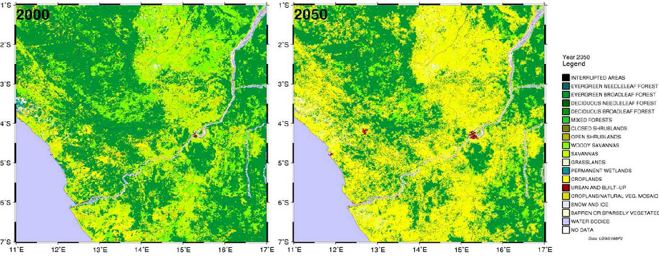
with the FAO estimate (FAO 2006). (3) LUC grid boxes were only affected, when a neighbouring grid box was already
been anthropogenically manipulated. In the area of the rain forest the last constraint ensures that a transformation
was mainly taking place along boundaries of woodlands. By contrast natural vegetation is preserved in the central
part of the rain forests (cp. Fig. 2). Regarding the southern zone of the Sahel,
desertification, due to improper agricultural practices and overgrasing, was leading to the transformation of
grassland to bare soil. Secondly, the higher-resolution land use and land cover grid (11 km2) was
adjusted to the REMO grid resolution (0.5°). Furthermore, the different land use and land cover categories were transformed to
the five surface parameters of REMO.
|
|
|
Fig. 2: Simulated land-cover on the basis of the 1/120° x 1/120° land-cover pixels
from the USGS/GLCC data set in the lower Congo region with a general transformation of evergreen forests
to cropland and an extension of urban areas between 2000 (left) and 2050 (right)
(Fig. 1 in Paeth et al. 2007).
|
|
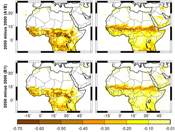
A linear change of land use and land cover is assumed for the transient land use and land cover scenario from 2001 to 2050.
The changes were superimposed on the seasonal cycle of vegetation. In comparioson to the
IPCC SRES B1 scenario a stronger land use and land cover scenario was
defined under A1B. It is assumed that the technological progress under B1 leads to a fairly efficient agriculture.
For this reason, the agricultural area is not as much expanding under the B1 land use and land cover scenario. However, both
scenarios are not leading to considerably different land use and land cover projections since population growth are the same under
A1B and B1. The spatial mean of the forest changes under the A1B scenario is identical to the FAO (2006) scenario,
that reduces the forest area of about 30% until 2050 (cp. Fig. 3).
|
| a) |
|
| b) |
|
|
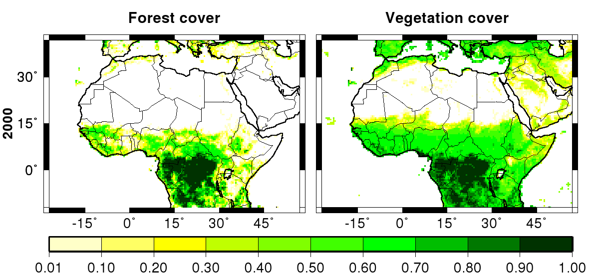
Fig. 3: (a) Present-day forest fraction and vegetation fraction and (b) prescribed
land use and land cover change scenarios until 2050. The top (bottom) row in (b) shows the
forest fraction and vegetation fraction changes for the A1B (B1) scenario
(Fig. 2 in Paeth et al. 2007).
|